Call on residents to help refine spatial vision for Blaauwberg Road Corridor
09 September 2024
The City of Cape Town has published the draft Local Spatial Development Framework (LSDF) for the Blaauwberg Road Corridor in Table View for public comment. The LSDF intends to address the challenges posed by historic planning dating from the 1980s, changes in the surroundings over the past 40 years, limitations on the corridor’s development potential, increasing congestion, and infrastructure challenges. Residents and stakeholders are encouraged to participate in refining the draft LSDF, and to submit their comments by 9 October 2024.
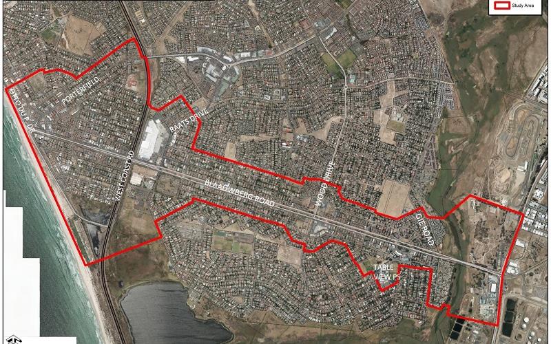
The draft LSDF addresses the areas adjacent to Blaauwberg Road, one of the most important transport routes in Table View. The corridor covers a distance of approximately 5km from Marine Circle in the west to the intersection with Koeberg Road and Potsdam Road in the east.
An LSDF determines the development vision for an area on a local level. The City uses the LSDF for guidance when making decisions about development applications and land uses, and public investment choices. In the end, these decisions very much determine what a neighbourhood will look and feel like a few years down the line.
'The intention of the LSDF is to develop Blaauwberg Road into a thriving urban corridor with world class destinations, walkable precincts and quality public spaces. It must be integrated with the surrounding natural assets and guide the way for sustainable urban development. I encourage local residents, business owners, and all other interested parties to be part of this process, and to submit comments on the draft, and to attend the information day on 14 September 2024, it is the ideal opportunity to ask your burning questions,' said the City's Deputy Mayor and Mayoral Committee Member for Spatial Planning and Environment, Alderman Eddie Andrews.
Context
Blaauwberg Road was developed in the late 1980s for low density suburban residential uses, based on a car centric development model with limited consideration of its interaction with the natural environment and open spaces.
Over the past 40 years, the urban footprint expanded to the north with the creation of new suburbs such as Parklands, Dunoon, West Beach, Sandown, Big Bay, Sunningdale, Rivergate and more. Congestion along Blaauwberg Road has subsequently increased, and with historic title deed restrictions limiting the development potential along this corridor.
In devising the draft LSDF the City relied on the 1998 Blaauwberg Road Growth Management Strategy as reference point. More than 25 years ago already, the strategy proposed that we should combine the mobility function of the Blaauwberg Road east-west arterial route with higher density mixed use development along the axis in order to fulfil the corridor's future potential.
Furthermore, the draft LSDF responds to and aligns with the Blaauwberg District Spatial Development Framework that was approved by Council in 2023. The DSDF identifies Blaauwberg Road and part of Marine Drive as prioritised areas for mixed land use, and higher density development; and pursues improved access to coastal opportunity areas such as the Table View beachfront.
The draft LSDF is informed by an interactive public participation process that took place in the second half of 2023, during which the insights of residents, business owners and other interested groups were taken into account.
Key spatial strategies for the Blaauwberg Road Corridor
- Plan for employment and improve access to economic opportunities – while the economy along Blaauwberg Road is currently service and retail based, there is a potential for a greater mix of economic opportunities
- To enhance access to the Marine Circle area and the coastline, which is a destination for sport and recreation, and tourism. Improved management can support economic development
- The Western section of the corridor between Marine Circle and the R27 can be developed further as a mixed use economic area. The shift to remote work brings opportunities to local business nodes and its proximity to the coast gives Blaauwberg Road a competitive advantage
- Development should be cognisant of the surrounding natural assets such as Rietvlei and the coast; and capacity constraints of the current services infrastructure
- Blaauwberg Road is a trunk MyCiTi route; increasing densities in the surrounding corridor will give more people access to opportunities along the route
- New development should provide a range of housing opportunities to accommodate varied income levels in support of a more inclusive and integrated city
The key policy outcomes: building a resilient corridor that can withstand the impact of climate change (wind, rising sea levels, storm surges); creating a vibrant and walkable urban area; managing growth responsibly; improving connections with public open spaces and natural areas; improving the mobility functions of Blaauwberg Road and the West Coast Road; and promoting sustainable streetscape designs.
The corridor is divided into four precincts, each with its own characteristics, sense of place, opportunities and challenges. The LSDF proposes development guidelines and interventions for each precinct:
Precinct 1: Includes the coastal line, a major local and tourist destination with views of Table Mountain and the Marine Circle area. This natural asset should be enhanced and the surrounding area upgraded, inclusive of the Marine Circle area.
Precinct 2: Stretches from the West Coast Road intersection to the Janssens Avenue intersection. This precinct includes several shopping centres.
Precinct 3: Stretches from the intersection with Janssens Avenue to just past Gie Road, with the nodes around Flamingo Square and Boy de Goede Circle.
Precinct 4: Stretches from past the intersection with Gie Road to the intersection with Koeberg/Potsdam Road, and includes the Potsdam Outspan site which borders the Killarney Racetrack.
The draft also proposes priority areas and projects for intervention to be implemented by City departments over the short- to long-term. These are based on the feedback received during the public participation process that the City hosted in September and October 2023 as part of the review of Growth Management Strategy for Blaauwberg Road.
How to comment:
'We are excited to collaborate with our local residents from the area as we are finalising the future spatial vision for this corridor to guide public and private development. Apart from the key outcomes, the LSDF must also promote partnerships and solutions to strengthen the local economy, and promote and protect the area as a quality tourist destination at the Marine Circle end in particular,' said Alderman Andrews.
End
Published by:
City of Cape Town, Media Office